Fort Bovisand
Fort Bovisand will always be a great launching point for some of the best diving in the south-west of England. It is a great place to run a club boat trip and also provides an excellent shore dive for training purposes.
The Fort
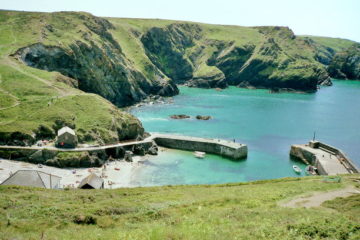
The fort has recently been taken over by Danny and Dave who run a company called Discovery Divers. There is now an accommodation block next to the fort with bunk rooms for divers with B&B at £15 per person per night (2014 prices, including breakfast but no bedding). There is a small dive shop and café by the water. If shore diving in the quay then you will need to use SMBs as there is a lot of boat traffic.
- ☎: 01752 492722
- ☎: 0773 9567752
Fort Bovisand is one of 22 forts built in the Plymouth area to guard against attack from the French in the 19th century. Although much of the Fort has been modernised, it still has a great atmosphere – especially in the underground drying rooms, which can be quite spooky late at night. Parking is available for both day visitors and those staying at the Fort. The cafe provides hot food, drinks and snacks.
Diving equipment can be hired from the large equipment stores situated on the harbour side, as well as air and Nitrox fills to 250 bar. A fully equipped dive shop is open six days a week from 9am to 5pm.
Dive Sites
The Habour
Perhaps the most distinctive feature of Fort Bovisand and offers good diving to about ten metres (depending on tides). It’s a voluntary marine conservation area and there are several lobsters lurking under rocks, as well as shoals of fish and even some coral. There is a really good nature trail marked out by a rope system leading you around the rocks to see a vast amount of plant life as well as the little creatures that live there. A perfect place for training beginners with plenty of life to give everyone something to look at.
Breakwater Fort
This is a circular, free-standing Napoleonic fort. There is a variety of wreckage on the sea bed around it at 16m. It has been used for many years as a training area for commercial divers and hence there are a lot of structures underwater that have been using for underwater cutting, welding and lifting. These include a fishing boat, a decompression chamber and a massive tubular framework. There is varied marine life on the wall of the fort from 3-8m, including a dozen recorded species of nudibranch. A delayed SMB should be launched prior to surfacing as it is likely if you are diving the fort so are other boats.
Hilsea Rock
Here large pinnacles rise from a depth of 35m to around 10m below the surface. They can be spotted from a boat if the visibility is good. There are sweeping gullies to dive in, with hard and soft corals. Hilsea Point Rock is suitable for all grades of diver. While slack water gives optimum conditions a drift dive is possible, before or after half tide slack, offshore of the pinnacle for the more experienced.
Located south of the old coastguard lookout hut above the cliff face (east of the point itself) the rock rises to just a few metres from the surface and descends over a broken rocky sea bed to 25m. The underwater scenery is spectacular and you can see most of the colourful species in the popular identification guides. Look out for yellow branching sponges and yellow cluster anemones. You can also see all of the UK wrasse species, John Dory, dogfish and, occasionally, an angler fish.
GPS: 50.17.317, 04.02.700
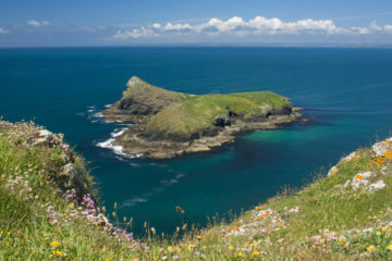
The Mewstone
A small, rocky island east of Fort Bovisand, which has a rather strange history. In 1744, a local man who had committed a minor crime was sentenced to live there for seven years. After he’d served his time, his daughter decided to stay on the island, got married and raised her own family there. Almost 200 years later, you can still see the remains of a house tucked away in the rocks on this barren outcrop.
The surrounding waters have incredible scenery and are great for drift dives. Just 10 minutes south of Plymouth Breakwater by RIB, off the east coastline, lies the Mewstone – a distinct mountain shaped rock that shelves down to the seabed. This means the area has hardly any silt compared with the rest of the local area, leading to excellent visibility and a hotspot for dogfish. The rock formation creates small underwater canyons which are home to a lot of sealife making this a great place for taking photos. The Mewstone slopes from 15-30m in places, so the site is great for scenic dives. The gradual increase in depth means it is easy to have a controlled environment in which to further a diver’s exposure to depth.
GPS: 50.18.100, 04.06.280
The James Eagan Layne
A favourite dive in the club, which is just in range of ocean divers, at 20m. The bow is still fairly intact and upright on the seabed with lots of life and is usually quite light. More information can be found on Divernet.
From the Fort you can access the James Eagan Layne and the Syclla as well as many other surrounding wrecks. It’s a very long drive to both the JEL and Scylla and we generally use about a whole tank of fuel for each boat on one return journey. Since they are located next to each other one boat journey can be used to access both wrecks. The only other place where it might be possible to launch from that is closer to these sites is Cawsand on the west side of Plymouth Sound. The Mewstone is a lot closer and easier to get to from here.
GPS: GPS 50.19.530, 04.14.700
HMS Scylla
This is a relatively new and intact frigate, sunk deliberately for divers. The wreck lies with its bow to the south-west, marked by three yellow diving buoys and a data buoy. The seabed is about 24m, but there is a lot to see on the upper decks (for ocean divers). There are a number of large holes cut in the side for diver access. Care must be taken with wreck penetration as the rooms are getting quite silty and the wreck is started to degrade. Again, Divernet has information on this wreck.
GPS: 50.19.640, 04.10.120
The Elk
A wreck of an old trawler that was used as a fishing boat and sank after hitting a mine in 1940. It lies in approximately 30-36m of water, sitting upright on the sandy bottom. There are clear signs of damage on the port side offering chance to penetrate for experienced divers. Apparently there are some huge conger eels that live in this wreck and plenty of gorgonia and deadmans fingers on the nearby reef. A good wreck dive but can be hard to find.
GPS: 50.18.240, 04.07.6655
Glen Strathallen
This is a great dive for beginners as there is a lot to see laid out over the seabed. The main parts that are left are huge boilers which are home to many fish. There is only one boiler upright and 5m proud of the seabed at 15m. Be careful though as it seems to be accumulating ropes and lines as time goes on. The boiler’s casing has come away revealing steam pipes. Look inside carefully, as a very large conger is resident. There are goldsinney wrasse are all over this site. The rest of the wreck is scattered around the boilers laying flat on the seabed. The surrounding area has a lot of kelp growth which attracts a lot of life, cuttlefish and scallops can be regularly seen here and some large shoals of fish. Look out for shrimps. There can be well over 30 in one of the pipes. There are also tompot blennies and nudibranchs (doridae, polycera and flabellina varieties). Ballen wrasse are both numerous and diver friendly. Common octopus can be seen here. For entry it is usually via a non-permanent shot and exit is either via the shot (usually placed next to the boiler) or DSMB. As this is shallow and along a potentially exposed coastline, surge can sometimes be present.
GPS: 50.18.9530, 04.07.6655
Persier
This wreck lies fairly upright, but partially collapsed, in about 30m of water. The wreck is protected from north and north-westerly winds, which usually means good visibility. Originally named War Buffalo, the ship was torpedoed in 1945, some distance from the Devon coast. After being hit, she was abandoned and thought to have sunk there. However, in 1969, a bell engraved with the name War Buffalo was brought up off wreckage found closer to shore in Bigbury Bay. It is believed the ship’s engines continued running her towards the coast until she finally came to rest there. This wreck is too far to get to if launching the club boats from Fort Bovisand, however use of a charter boat or launching from an alternative slip would allow access. More information can be found at Divernet.
GPS: 50.17.115, 03.58.138
0 Comments